Category: Uncategorized


INTERVIEW WITH OUR NEWEST TRUSTEE: BARRY JOHNSTON ANSWERS 10 QUESTIONS

How did you decide to move from Virginia to Wellfleet?
We have owned a summer house in Wellfleet since 2007 and lived on a farm in the Blue Ridge Mountains of Virginia. In 2023 we decided it was time to downsize and Wellfleet became our home.
Tell us about your conservation efforts in the Blue Ridge Mountains.
When we renovated our old farm house we discovered it was built around a prerevolutionary log cabin which we restored. We placed the farm in a conservation easement and over the years we removed invasive species, promoted wild flowers and native plants, created trails and conducted wildlife surveys with the Smithsonian Institute. As a Virgina Master Naturalist, I volunteered to preserve Virginia’s natural habitat including as a National Park volunteer to protect rare native plants in the Shenandoah National Park.
What is your educational and professional background?
I am an economist/econometrician by training. I worked for 27 years with the International Monetary Fund (IMF) in Washington DC and before that in London at the Bank of England and Treasury, and in Basel Switzerland, specializing in finance. I now teach on the financial effects of climate change and bio diversity loss.
Who and/or what got you interested in the Wellfleet Conservation Trust?
My wife Pat and I are gradually finding our way in the Wellfleet community and we were looking for volunteer opportunities. I thought the WCT would be a good fit and I am very appreciative to have been selected as a trustee.
What are your interests and experiences that you bring to the W.C.T.?
What I learnt in Virginia is that conservation is not just a question of protecting land. Stewardship of the land and education is a vital part of conservation. I hope my background will allow me to contribute on that.
What are some early influences that inspired your interest in nature/conservation?
I grew up in Northern Ireland surrounded by open country side. My family were from farming stock. It was part of growing up to appreciate and spend time in nature.
What Cape and Wellfleet activities and places do you especially enjoy and why?
Swimming in Great Pond and sailing my catboat for the peace and tranquility.
What Wellfleet or Cape organizations do you belong to?
We are members of Mass Audubon, the Friends of the Cape Cod National Seashore and Nauset Newcomers.
Tell us about your family members.
My wife Pat of 48 years is an avid gardener. My eldest daughter lives in Brooklyn, my second daughter lives in Switzerland with our three grand-children and our son lives in Scotland. Spending time on our farm in Virginia instilled them with a love of nature. Our son is a marine biologist.
What is something surprising about you that not too many people know?
I am a fan of minimalist music.
Bonus question – What is something else you would like to say to our readers?
The WCT will only be able to conservation a relatively small amount of land. To preserve our habitat, the conservation effort must be much bigger and depends on you. Start by creating a home environment to attract the birds, butterflies and bees — plant natives and remove invasives.
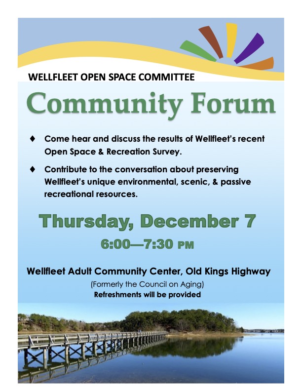
Community forum on the Open Space & Recreation survey
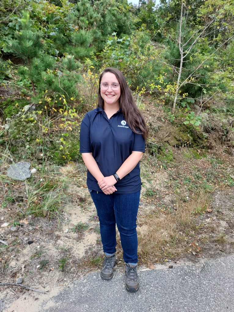
Meet Our New AmeriCorps Member, Emily Gilot
The Trust is delighted to introduce you to this year’s AmeriCorps member, Emily Gilot. She is assigned to WCT on Tuesdays, spends two days assisting the Provincetown Conservation Commission, and the rest of the time on projects elsewhere on the Cape. Here is the transcript of the e-interview we conducted with Emily to get to know a little bit about her as she begins her time here.
Being a part of AmeriCorps 25th year seems very special. Any more thoughts on this?
It is special and I did not realize this when I started the AmeriCorps Cape Cod program. However, each service project I have done, each Cape Cod resident I have met in the last 7 weeks, the more I feel how special it is. There are signs all over the Cape of AmeriCorps impacts, from marsh boardwalks still standing, to elementary school gardens that rely on AmeriCorps members to prepare for spring planting. The alumni community on the Cape is fantastic and it has been wonderful getting to meet and serve with many of them the last few weeks. Doing so has instilled in me a sense of pride in the service I am doing here on the Cape, that what I am doing is having an impact and will add to the program’s legacy.
What were some of the best parts of orientation?
During orientation we got a taste of everything we might get to do doing group service projects. It was a mix of in the field, such as learning how to use power tools for trail maintenance, and in the office, with lectures on Cape History, First Aid, and the County’s Sheltering System. My favorite trainings involved being on the water. We went on a marine nature walk with a scientist from the Center for Coastal Studies and received an introduction to shellfish propagation while digging up quahogs with Chatham Shellfish Department.
What are your first impressions of Wellfleet?
I had never been on the Outer Cape prior to this fall and I was a little surprised at the ruralness of the area. That being said, I much prefer it to the hustle & bustle of the more developed parts of the Cape. One of the major benefits I am finding to living in the Wellfleet house is the limited light pollution, which is a testament to the community, the proximity to the National Seashore, and the more rural nature of the area. I also love that I can see the sun rise and set over the water in the same day, going from one side of town to the other.
What assignments will you be doing with the Wellfleet Conservation Trust?
While serving with WCT, I will be assisting with trail maintenance and mapping. I will also be assisting with organizing and updating various documentation for all the properties the Trust owns and/or works with
What WCT properties have you viewed so far?
Denny[O’Connell] and Michael [Fisher] have taken me to a number of WCT properties, including Box Turtle Woods and Herring River Overlook. I love the combination of woods and marsh on many of WCT’s properties and I am excited to explore them more over the coming months. In Wellfleet, I have spent the most time at the town pier and beach. I love looking for different animals and going beach combing. Watching the seals feed in the harbor has been awesome and, while sad at times, I have been really enjoying looking for Mola Mola (Sunfish).
Did you experience Wellfleet Oysterfest?
I had a great time at Oysterfest. To my understanding, it’s oysters that Wellfleet is known for. It was wonderful to see how the community supports the shellfish industry and vice a versa. I volunteered Sunday morning, assisting with the recycling stations, which was a great opportunity to assist the Wellfleet Oyster Alliance with their public outreach. I also ended up staying for the entire shucking contest that afternoon and wow. Great personalities up on stage, the crowd was so into it, and the lobster auction was so wholesome. I did try fried oysters for the first time and the jury is still out on whether I like them.
Tell us a little bit about your background and where you grew up.
I am originally from along the SE’rn Connecticut shoreline and am part of a family of 4, plus three cats I miss dearly.
Are you looking forward to winter on Cape Cod?
Oddly enough, I am. Growing up along the Connecticut shoreline, I am no stranger to a New England winter. My family has always gone on beach walks in the winter time so I expect to do the same here. The ocean keeps us in Connecticut and the Cape a little warmer than the rest of the region and I am looking forward to having the area to myself for a few months. As a degreed weather nerd, I am interested to see how we fair with Nor’easters this winter and am excited to track the systems then watch the waves at the local beaches when they do come through.
Did you have teachers or courses that fostered your interest in science/environment/nature?
My high school was special, from the enthusiastic and compassionate teachers to the e marine-science focus it had. I got to take maritime history and learn about a variety of marine science topics from biology, to fisheries management, aquaculture, safe boating, physical oceanography, just to name a few. I eventually chose atmospheric science (meteorology) to study in college and had some amazing professors in my department. My favorite classes in college were some of the intro classes to my major, where a lot of basic weather questions were answered (why is the sky blue, what causes a thunderstorm, etc.). In terms of more advanced classes, I really enjoyed synoptic meteorology which is the study of large scale features (highs, lows, fronts, etc.) and tropical meteorology (hurricanes and also phenomena like El Niño). Outside of my major, I loved classes I could connect to weather such as ‘Intro to Emergency Management’ and ‘The Role of Hazard Mitigation in Community Planning’.
Who or what have given you inspiration for conservation of the natural world?
My interest in conservation definitely can be traced back to growing up where I did. I was constantly exposed to conservation efforts in the area, from walks at the local nature center to exploring the local aquarium. I also spent a lot of time out on and along the water, visiting my grandfather’s beach cottage year-round. Having developed deep connections with my local landscape throughout my childhood, the desire to assist conservation efforts just feels second nature.
Tell us about an accomplishment that we wouldn’t know about.
Something I am really proud of is earning my 25-Ton Inland Master Captain license this past spring. An instructor at my previous AmeriCorps position taught the classes. I was able to apply my sea time from working with them and from boating with my family to qualify for the license. I know I want to work, if not live, near the coast and I am looking forward to employing this license to achieve that goal. Additionally, I worked for a company that forecasted for and routed private and commercial vessels all around the world for two years after graduation. I want to see, maybe one day by boat, at least some of the places my clients travelled and this license could help me do that
Welcome aboard, Captain Emily!
Woodlands, Marsh, Historical District: WCT 15th Annual Guided Walk
Contributors: Mary Rogers, Mark Robinson, and Dwight Estey.
Editors: Alice & Bill Iacuessa
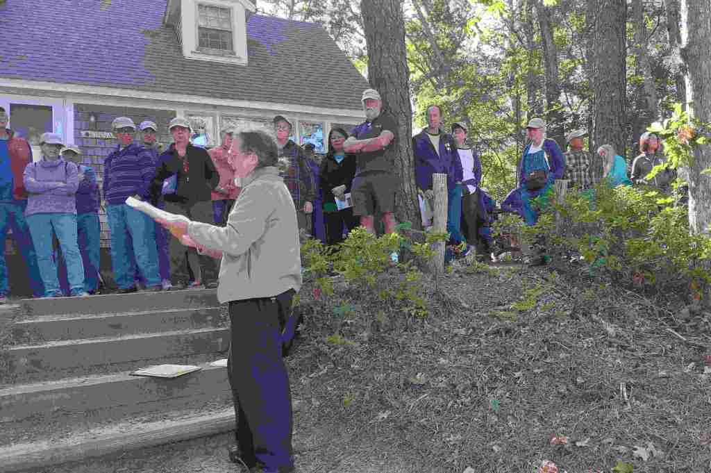
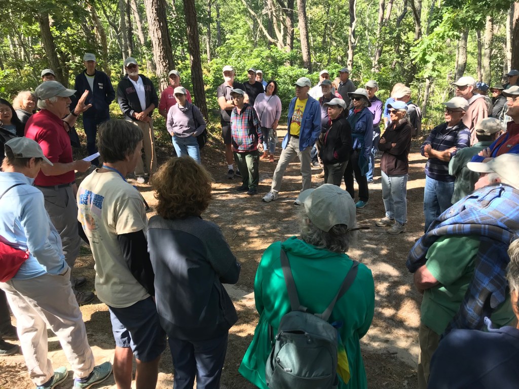
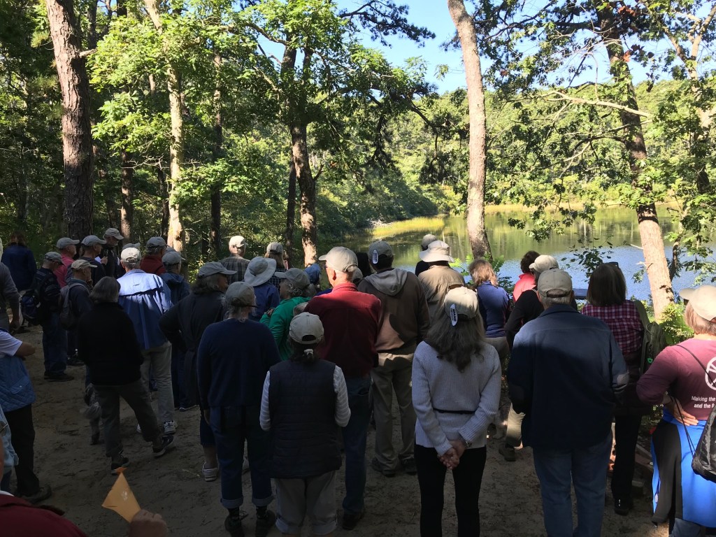
The 2023 Wellfleet Conservation Trust (WCT) walk was delayed, as were the previous two. As in the 2019 (13th) walk, the weather delayed it by a day. The 2020 walk was delayed two years due to covid and became the 2021 (14th) walk. On a positive note, the weather was warm and sunny for all three.


The plan for the walk
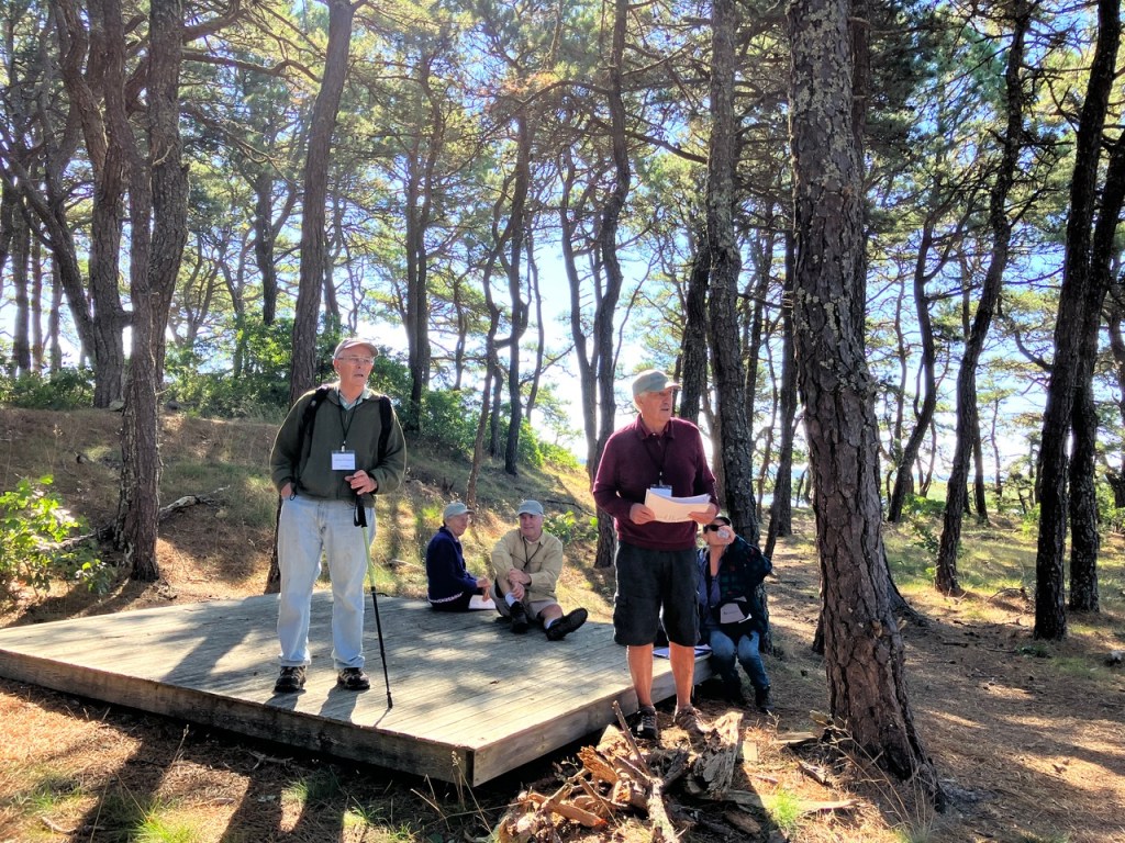
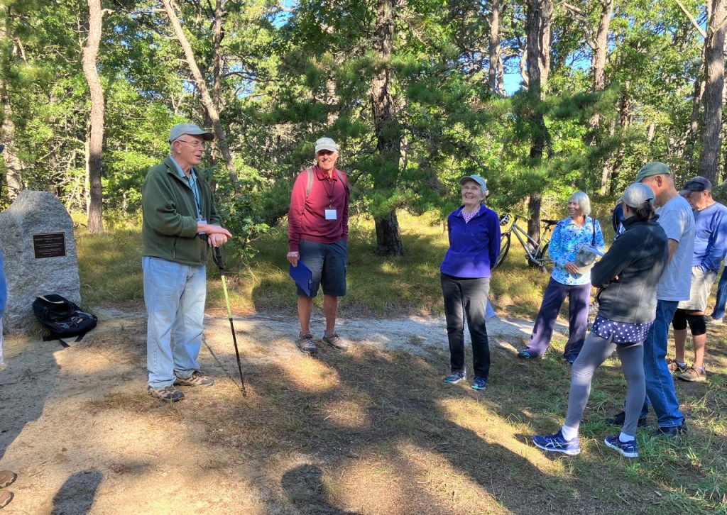
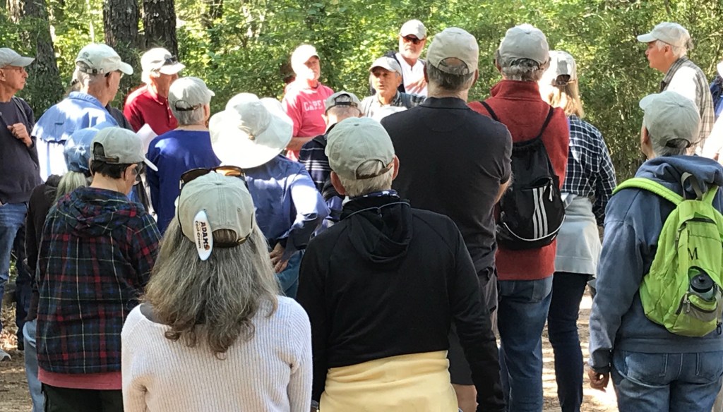
The 2023 walk started in the middle of the Fox Island Marsh and Pilgrim Spring Woodlands Conservation Area. Denny O’Connell, President of WCT, opened the walk at the Robert Hankey Memorial Stone by welcoming the 35 participants. Robert Hankey was a founding member of WCT and was directly involved in the creation of this conservation area.
Bill Iacuessa, WCT Vice President and organizer of the walk, explained that the walk would go through three distinct areas, woodlands (mostly along narrow paths), along the edge of a marsh, and finally through an historical area of South Wellfleet.
Speakers
This year, the speakers concentrated on the history of the area. The first stop was at the bench dedicated to the Ira Ziering family. Denny described how instrumental Ira was in helping to acquire a few of the parcels of the area. He also pointed to the Trust’s newest acquisition, the nearby Bouchard property.
Mary Rogers hypothesized on the name of a particular area of the walk, Pilgrim Spring Woodlands. She suggested it could have been the possible location of the natural spring that gave Pilgrim Spring Woodlands its name. She also described the Cape Cod Pilgrim Mineral Spring Company that produced bottled tonic water prior to World War I.
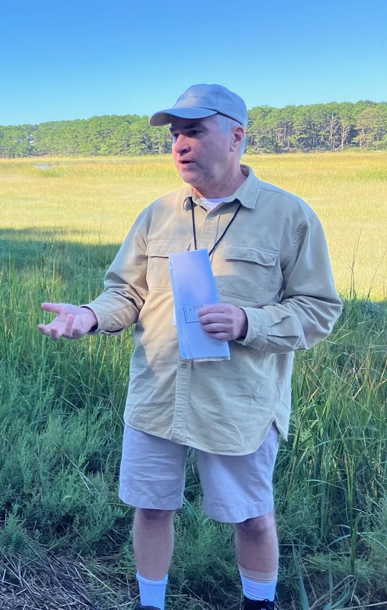
At the edge of Fox Island Marsh, Mark Robinson, Executive Director of the Compact of Cape Cod Conservation Trusts, spoke about how the WCT led the partnership that resulted in the Town, Commonwealth, and private donors raising $4.5 million to acquire 68 acres of upland for conservation. Mark was involved in the negotiations and fundraising including liaising with the Commonwealth. This assemblage is the largest conservation area north of the Orleans rotary and is an important habitat for the endangered Diamondback Terrapin.
Further along the marsh and into the woods, Denny told the story of the burial that took place a number of years ago. It was the burial of a cast iron bath tub that was acquired with the land. Trustees and AmeriCorps members, dug it out of its hole, widened the hole, turned the tub upside down and buried it. Photos of the event were passed around.
At Whalebone Point. Mark Robinson described the vista that came into view, including Indian Neck, Blackfish Creek, Lt Island, the bridge to the island, and Old Wharf Point.
As always, these walks are a group effort involving a number of our trustees.
Growth of the town
Dwight Estey used two locations to describe the relationship between the growth of the town during the 19th century driven by the mackerel fishery and today’s Paine Hollow Historic District. At Paine Hollow Landing he pointed out the abandoned location of the Southern Wharf at the end of Old Wharf Point and the long-gone Townsend Salt Works which was near where they were standing. The wharf served a few dozen two-masted and three-masted ships primarily used in the mackerel trade. Among its buildings was a salt-shed used for salting down the catch. Overall, from 1820-1850 the town population grew from 1,400 to over 2,400, schools increased from 6-12 and there were up to 100 boats in the mackerel trade.
Moving to the corner of Paine Hollow Road and Pleasant Point Road (formerly known as Hinckley Corner) he referred to Irene Paine’s book, Eva and Henry, as a reference to better understand the area. Prior to 1800 there were scattered houses of the Youngs, Riches, Wiley’s and Lombards – among others.
Within the historical district there are now seven houses associated with the Paines. They were all built in the early 19th century when the Paines were involved in the fishery. The purchase of the Southern Wharf by Collins Cole and Nathan Paine began a long history of both families settling down in this area that is sometimes referred to as “the road that time forgot.”
The contingent was told the tale of Isaac Rich who was born (1801) on Pleasant Point Road. The eldest of ten children, Isaac at age 14 moved to Boston with his father to find employment. Starting by pushing an oyster cart, at age 19 his father died and Isaac opened an oyster stall. Using earning he first invested in ships and then Boston real estate. A devout Methodist, Isaac died in 1872 as one of the richest men in Boston, leaving his entire estate for the founding of Boston University. Though worth 1.5 million when he died, the Great Fire of Boston removed half that worth.
The last site discussed was that of the Robert Young Cemetery. Started in 1799 its last burial was 1854. The stones were moved to the South Wellfleet Cemetery but the bodies were not. Only eight of the stones still exist although over a dozen bodies were buried there.
Can we have both open space and affordable housing?
Seth Rolbein’s latest post, Buying open space, pushing big-lot zoning, provides a straightforward discussion of the need and possibilities for affordable housing on Cape Cod. The loss of affordable housing has transformed daily life, including hollowing out communities, increasing traffic, and endangering health.
Seth shows clearly how the loss of affordable housing was not due to protecting open space for conservation and recreation. Instead, decades of zoning battles that emphasized single-family homes and ever-larger lot sizes drove up costs “and ignored alternatives like more density in well-selected places.”
Land Trust Alliance’s new Resource Center

Herring River Overlook
Last month, the Land Trust Alliance opened its new Resource Center.
It’s described as “a one-stop-shop for volunteers, staff and board members of land trusts and other conservationists to learn, connect and grow.” The Resource Library holds more than 3,000 documents, courses, events and other materials related to land conservation.
There’s too much there to give a detailed summary, but it’s easy to browse. The Library is interesting to explore and can be valuable to anyone interested in conservation.
The Alliance has nearly 950 land trust members across the country, including Wellfleet Conservation Trust. The members are community-based, nonprofit organizations that work to conserve land by acquisitions or conservation restrictions. They also manage or restore land once it has been conserved.
Annual Walk, September 17, 2022
By Bill Iacuessa
The 14th annual Wellfleet Conservation Trust (WCT) walk was held on Saturday, September 11. Due to COVID the walk was cancelled twice, so it was 3 years in the planning but well worth the wait. Denny O’Connell, President of WCT, welcomed the walkers at the Long Pond parking lot. Bill Iacuessa, organizer of the event, oriented the group to the unpaved roads and trails of the walk which are almost exclusively in the Cape Cod National Seashore. The highlights included Spectacle Pond, Kinnacum Pond and Gross Hill. As usual there were stops and speakers along the way.
Before heading off, Bill passed out photos of the ice house that existed along Long Pond in the late 1800s and early 1900s. Arriving at Spectacle Pond, John Portnoy, a scientist at the National Seashore for many years, spoke about the geology of Wellfleet ponds and Spectacle Pond in particular. Mary Rogers entertained the group about the quirky ways the names of streets and unpaved roads in town are changed.
At Kinnacum Pond, David Wright explained the rich life of Dr. David Belding, who built the cottage on the pond. The cottage is on private land and not normally accessible to the general public. Dr. Belding was a shellfish biologist and medical doctor. His work ushered in a century of purposeful aquaculture in Wellfleet, resulting in today’s robust and sustainable system of grants, licensing, propagation and management.
Along Isabell Way, near Gross Hill, Dwight Estey spoke about the lives of the famous Gross sisters, as they came to be known. Copies of the daguerreotype of the sisters, made in 1851, were passed around. When taken, the eldest was 85 and the youngest 57. It would be the only time that the sisters were all together.
The final section of the walk, along a narrow trail, passed by a grove of Tupelos which are known for their beautiful fall foliage. This grove is on high ground, an unusual site for this tree, which loves a moist, low-lying environment. The trail also passed by an abandoned foundation whose story is now lost. It was a perfect day weather wise and over 75 walkers enjoyed the trails and presentations.


Wellfleet Conservation Trust Receives Extreme Terrain Clean Trails Program Grant
The WCT would like to thank the Extreme Terrain Clean Trails Program for their recent grant of $250. The moneys awarded will be used for equipment to help keep our trails clear and for various trail improvement projects.
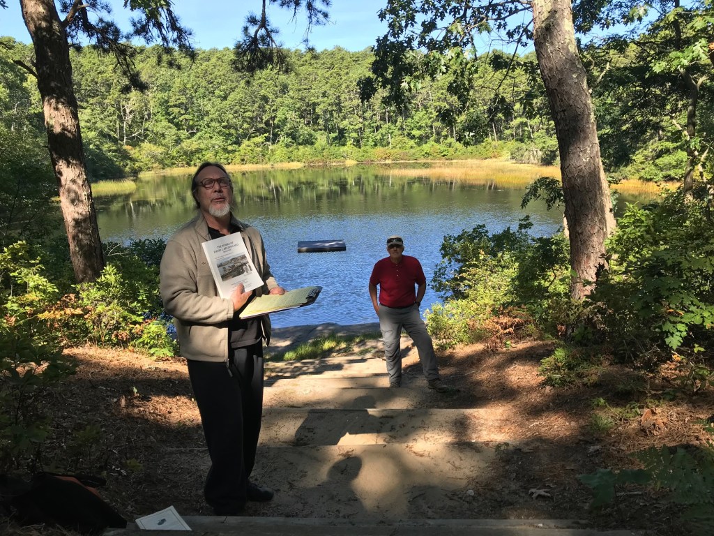
Video of New Herring River Overlook Trail
A new video for the Herring River Overlook Conservation Land and Trail has just been released. As with our other videos, thanks go especially to Mary Doucette, advised by Mike Fisher.
The Herring River Overlook Conservation Land and Trail consists of 18+ acre uplands property with a 1 mile trail consisting mainly of a pine-oak woodland. The northwestern portion of the trail offers panoramic views of the Herring River, Griffin and Great Islands and Cape Cod Bay.
Length of Trail & Total Conservation Land Area: 1 miles; 18.3 acres
Area description: This beautiful 18.3 acre uplands property is a typical coastal heath that is succeeding to a pine-oak woodlands. It hosts about a 1 mile walking trail loop which starts and ends at the parking area. In the northwestern stretches, the ridge offers spectacular views of the Herring River, Griffin and Great Islands and into the Cape Cod Bay. Previously the land had been part of the surplus land holdings of the Chequessett Club, known for its golf, sailing and tennis activities. The Trustees of Chequessett Club had a strong preference to see the land in conservation and open to the public. This land has never been inhabited in modern times. Geologically, the land is an outwash plain, a remnant of the last glacial age of approximately 25,000 years ago. The land was graciously donated by Ms. Jacqualyn Fouse, a local resident, to the Wellfleet Conservation Trust in 2020.
Location: The trail head is at 1000 Chequessett Neck Road; GPS 41.92820° N, 70.06226° W
Directions: Exit Route 6 on Main Street; follow to the end of the commercial district; Left on Holbrook Ave; Right on Chequessett Neck Rd.; follow 1.9 miles.

You must be logged in to post a comment.