Please join us for a focused Annual Meeting on your Wellfleet Conservation Trust. Due to pandemic concerns, we have not been able to meet in person since our August 2019 Annual Meeting, but we have some statutory requirements, so we hope you can join us via Zoom. There will be a brief review of recent activities, a video presentation of our new Herring River Overlook site, and election of Trustees for terms ending in 2023 and 2024.
We miss meeting in person but plan for a regular, in-person annual meeting in the summer of 2022.
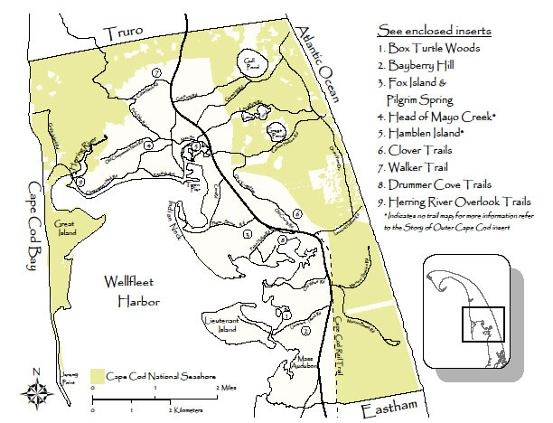
For more than 15 years, the Wellfleet Conservation Trust (WCT) and two Wellfleet-town committees have worked in partnership to provide walking trails on designated conservation lands. All of these trails are outside of the Cape Cod National Seashore and the Wellfleet Bay Sanctuary of Mass Audubon who have some of their own nice trails. On the WCT website, see the down-loadable map called “Wellfleet Open Space and Conservation Lands” for all the conservation land in town.
WCT works most closely with the Open Space Committee (OSC) which is charged with evaluating town owned lands and designating additional lands for acquisition for conservation purposes, including installation of trails, i.e. “passive recreation”. The OSC has had its eye on currently town-owned land which would have a best use as conservation land whether just for pure conservation purposes without trails, or with trails. The OSC then works through Town Meeting to get the land placed under the care and custody of the Conservation Commission (ConsCom).
This has been a very effective partnership leading to trails on eight of the areas designated for conservation. In these areas, the underlying lands are owned variously by WCT and the Town, under the care and custody of ConsCom. The underlying ownership divisions on the land are intentionally invisible so the public can enjoy the underlying conserved land without interruption. The land is cared for by feeownership for conservation purposes and protection under contractual conservation restrictions. In some places the land is owned by the Town with a conservation restriction held by WCT. In other places, it is the reverse. See the map below called WCT and Town Conservation Trails which shows the locations of these trails.
The partnership then maintains the trails through work parties consisting of the WCT trustees, and volunteers, along with members of the town committees. There are times when the efforts are greatly supplemented by the members of AmeriCorps of Cape Cod who bring skills and endurance through youth and contagious enthusiasm.
There are trail maps and guides, in hard copy, that are provided at various public locations such as the Library and Town Hall. Also, these trail maps and guides are available for download or printing from the WCT website.
Enjoy your walks in Wellfleet. There is a lot to appreciate.
The WCT would like to thank the Extreme Terrain Clean Trails Program for their recent grant of $250. The moneys awarded will be used for equipment to help keep our trails clear and for various trail improvement projects.
After much consideration in regards to the latest Wellfleet Board of Health Covid requirements and recommended guidelines, the Wellfleet Conservation Trust has decided to cancel our annual guided walk scheduled for 11 September.
Normally the walk has involved over 75 people. The Health Board recommends that all people not from the same household should maintain six feet of distancing and when closer, masks should be worn, even outside and regardless of vaccination status. Trying to keep six feet physical distancing and masking among our normal numbers would be extremely difficult and would eliminate the group discussions and socializing that walkers have enjoyed in the past.
The walk we planned this year will still be there next year when we will try again. We support the Board of Health in their concern for keeping Wellfleet a safe healthy community.
A new video for the Herring River Overlook Conservation Land and Trail has just been released. As with our other videos, thanks go especially to Mary Doucette, advised by Mike Fisher.
The Herring River Overlook Conservation Land and Trail consists of 18+ acre uplands property with a 1 mile trail consisting mainly of a pine-oak woodland. The northwestern portion of the trail offers panoramic views of the Herring River, Griffin and Great Islands and Cape Cod Bay.
Length of Trail & Total Conservation Land Area: 1 miles; 18.3 acres
Area description: This beautiful 18.3 acre uplands property is a typical coastal heath that is succeeding to a pine-oak woodlands. It hosts about a 1 mile walking trail loop which starts and ends at the parking area. In the northwestern stretches, the ridge offers spectacular views of the Herring River, Griffin and Great Islands and into the Cape Cod Bay. Previously the land had been part of the surplus land holdings of the Chequessett Club, known for its golf, sailing and tennis activities. The Trustees of Chequessett Club had a strong preference to see the land in conservation and open to the public. This land has never been inhabited in modern times. Geologically, the land is an outwash plain, a remnant of the last glacial age of approximately 25,000 years ago. The land was graciously donated by Ms. Jacqualyn Fouse, a local resident, to the Wellfleet Conservation Trust in 2020.
Location: The trail head is at 1000 Chequessett Neck Road; GPS 41.92820° N, 70.06226° W
Directions: Exit Route 6 on Main Street; follow to the end of the commercial district; Left on Holbrook Ave; Right on Chequessett Neck Rd.; follow 1.9 miles.
The Wellfleet Conservation Trust is planning its 14th annual guided walk to take place the morning of 11 September. The walk will be in the area bounded by Gross Hill Road, Ocean View Drive, and Long Pond Road. It will be almost exclusively on dirt roads and paths, about 2.4 miles in length with some moderate hills. We will have short discussions/lectures at points of interest. The walk is FREE to participants and expected to take about 2.5 hours. Walkers who have not received a Covid vaccination are asked to wear masks since social distancing will not always be possible.
This year, walkers are asked to register in order to participate. Parking will be at a premium so we encourage carpooling when possible.
Plans have not yet been finalized, but WCT intends to offer the Annual Guided Walk in September. The target date is Saturday, September 11, and the route will follow dirt roads and trails from Long Pond to Spectacle Pond and back. It should be about a two mile walk. Timing and parking logistics need more planning, so you will need to follow our website and Facebook page for more details as they become available.
Our newest WCT conservation area, now dubbed Herring River Overlook (HRO), offers woodlands, wetlands, meadows, and incredible views of the Herring River estuary.
As the Herring River restoration project proceeds, these views will become even better. They’ll provide a tutorial on the restoration of the historic salt marsh, with its diverse flora and fauna.
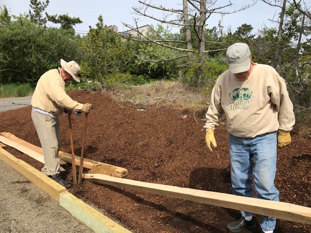
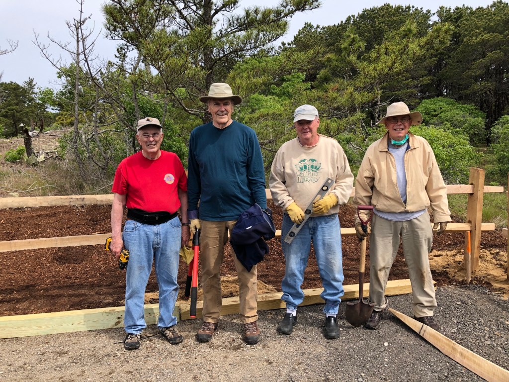
Trustees and friends held a small work party on June 1 to complete the parking area for a trail through the HRO property, clear the trail, and add steps where needed. Fortunately, it was a sunny day with mild temperatures. The photos here give you some idea of the work involved and also what the finished trail will be.
MIke FIsher, Dave Koonce, and Denny O’Connell building a slit rail fence around the parking areaMike and Dave digging post holesAmericorps worker, Mary Doucette and Barry Turnbull trimming a treeDenny, Dave, and Mike measuring a post holeMike setting steps on a steep area at the start of the trailDenny, Chip, Dave, and Mike after completing one section of fence
A new video for the Drummer Cove conservation area has just been released. Thanks go especially to Mary Doucette, advised by Mike Fisher.
The Drummer Cove area is remarkably varied for its 11+ acres. It is also unusual for offering a 1+ mile trail with easy access.
Length & Extent of Trail: 1.1 miles; 11.3 acres plus easements
Area description: The Drummer Cove Conservation Area includes salt marsh, tidal flats, coastal bank and oak pine forest on its upland. The entire area is within the recharge area to Drummer Cove and as such falls into the Wellfleet Harbor Area of Critical Environmental Concern. The land is in State designated Priority Habitat for rare species. The four benches provide great views of the Cove.
Location: The trail head is at 170 Pond Ave in South Wellfleet. 41.91415, -70.00165
Directions: Exit Route 6 heading west for approximately 0.5 miles on Paine Hollow Road to the first stop sign. Turn left on Pleasant Point Road for approximately 0.25 miles. Turn left on to Pond Ave for 0.3 miles, the last part being a dirt road to a parking area at the trail head.
An analysis of the use of our WCT website shows that many visitors to the site are interested in exploring the conservation areas and trails. That’s especially the case in July and August.
Responding to that need, Mary Doucette, our Americorps worker, has produced a terrific video for the Fox Island and Pilgrim Spring area.
It’s now posted in our video showcase, which will eventually contain additonal WCT videos (currently just this one).


You must be logged in to post a comment.