Thirty-eight participants thoroughly enjoyed the First Day Walk 2024, The Gut to the Herring River Overlook. Bright skies greeted the walkers as they arrived at the National Seashore Great Island parking lot. Bill Iacuessa, Vice-President of the Wellfleet Conservation Trust (WCT), welcomed the participants and described the walk saying that the Trust and the Friends of the Herring River (FHR) were delighted at the turnout. Dale Rheault, Chair of the Friends of the Herring River, was introduced, and spoke briefly about the role of the FHR. Speakers Alice Iacuessa and John Portnoy were introduced. Alice and John, are former members of the FHR board and along with Barbara Brennessel, co-authors of Tidal Waters, A History of Wellfleet’s Herring River.
The walk began by heading down the hill to the beach near the mouth of the Herring River and the Gut. Bill gave a short orientation, and then Alice talked about the recent archeological research on Native American and English colonial use of Great Island. The walk proceeded down the beach a bit further toward the dike where John talked about the history of the dike and benefits of removing it which will restore the salt marsh incrementally over a number of years.
The walk proceeded up to Chequessett Neck Road and crossed over the dike. Although not open yet, the completed temporary bridge was in full view of the walkers. Continuing along the participants reached the parking lot of the Herring River Overlook Conservation Area where Denny O’Connell, President of WCT met them. Denny described the acquisition of the 18-acre parcel, the significance of its location, and the creation of the one-mile trail. The walk continued with short stops where Denny pointing out features, the most significant being the views of the Herring River from above.
The walkers retraced their steps. Just before the parking lot, at the gravesite of a Native American woman, Alice talked about how and why it was placed at this location. The two-mile, two-hour walk concluded at noon.
Photos, taken by Dwight Estey, board member and former president of the Wellfleet Historical Society and Museum, can be viewed at WCT-FHR – First Day Walk – 2024.
WCT participated in the 2023 Coastsweep on Monday. Volunteers picked up tally sheets at Mayo Beach, then fanned out to a dozen other sites in the Wellfleet area.
Getting assignments for the cleanup
Over 40 came to collect artificial debris–mostly plastics, which soil our beaches, endanger wildlife, and pose immediate hazards to humans. The beach pickup addresses just some of the accessible portion of the much larger problem of polluted oceans.
Duck Creek overwash, just one of many sites for the cleanup
Coastsweep is part of the International Coastal Cleanup organized by Ocean Conservancy in Washington, DC. Volunteers from all over the world collect marine debris—trash, fishing line, metal scraps, and other human-made items. They make beaches cleaner and safer. Categorizing and tallying their harvest helps reveal sources of marine debris sources and potential solutions.
Not all of the debris we encountered could be picked up and carried in bags back to the start point.
Large debris, noted but leftFlag, left as necessary for monitoring the overflow at Duck CreekNatural debris at the wrack line
Contributors: Mary Rogers, Mark Robinson, and Dwight Estey.
Editors: Alice & Bill Iacuessa
The 2023 Wellfleet Conservation Trust (WCT) walk was delayed, as were the previous two. As in the 2019 (13th) walk, the weather delayed it by a day. The 2020 walk was delayed two years due to covid and became the 2021 (14th) walk. On a positive note, the weather was warm and sunny for all three.
The plan for the walk
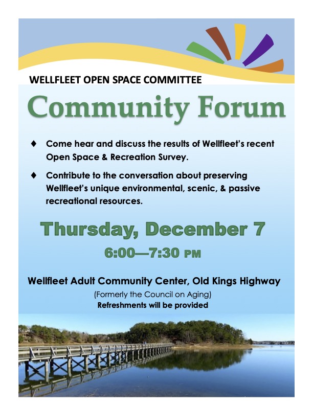
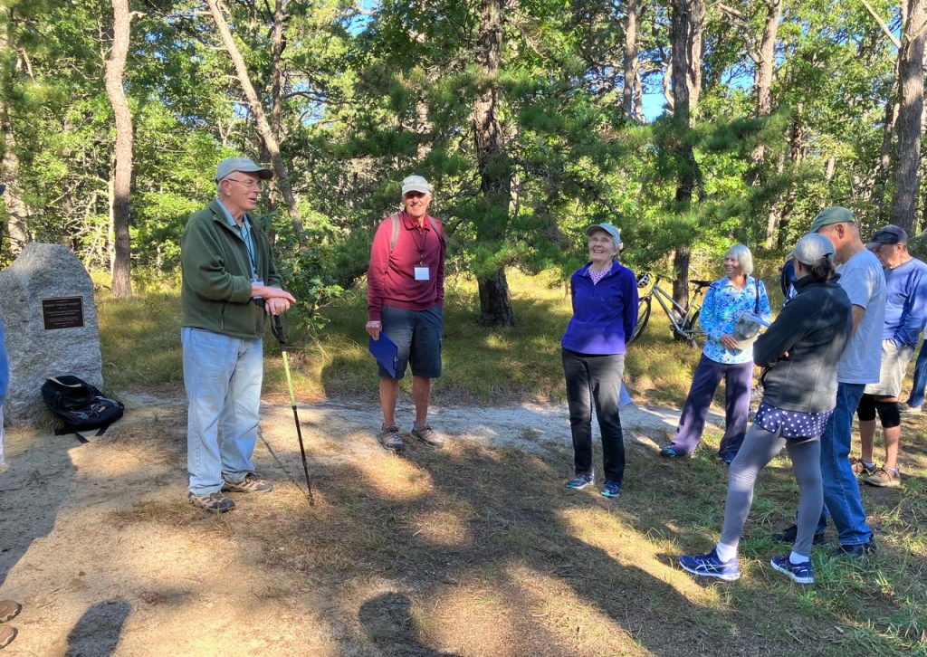
The 2023 walk started in the middle of the Fox Island Marsh and Pilgrim Spring Woodlands Conservation Area. Denny O’Connell, President of WCT, opened the walk at the Robert Hankey Memorial Stone by welcoming the 35 participants. Robert Hankey was a founding member of WCT and was directly involved in the creation of this conservation area.
Bill Iacuessa, WCT Vice President and organizer of the walk, explained that the walk would go through three distinct areas, woodlands (mostly along narrow paths), along the edge of a marsh, and finally through an historical area of South Wellfleet.
Speakers
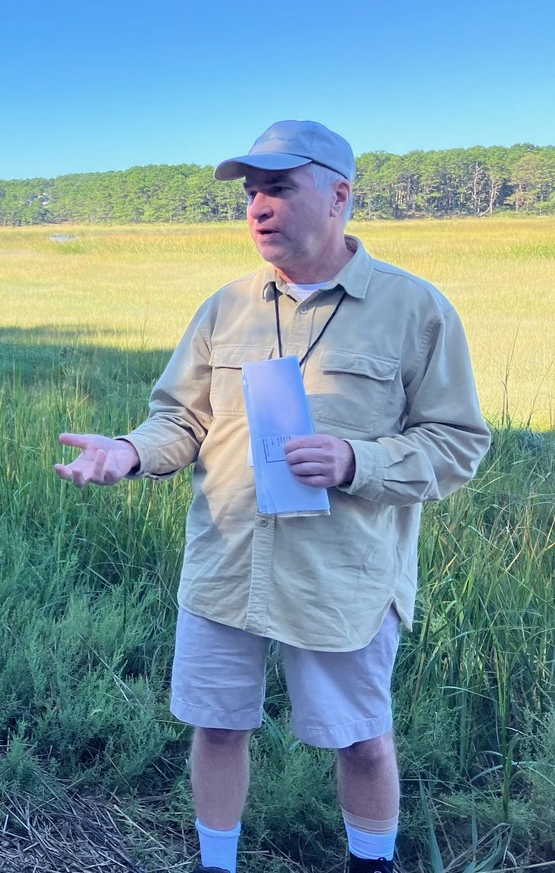
This year, the speakers concentrated on the history of the area. The first stop was at the bench dedicated to the Ira Ziering family. Denny described how instrumental Ira was in helping to acquire a few of the parcels of the area. He also pointed to the Trust’s newest acquisition, the nearby Bouchard property.
Mary Rogers hypothesized on the name of a particular area of the walk, Pilgrim Spring Woodlands. She suggested it could have been the possible location of the natural spring that gave Pilgrim Spring Woodlands its name. She also described the Cape Cod Pilgrim Mineral Spring Company that produced bottled tonic water prior to World War I.
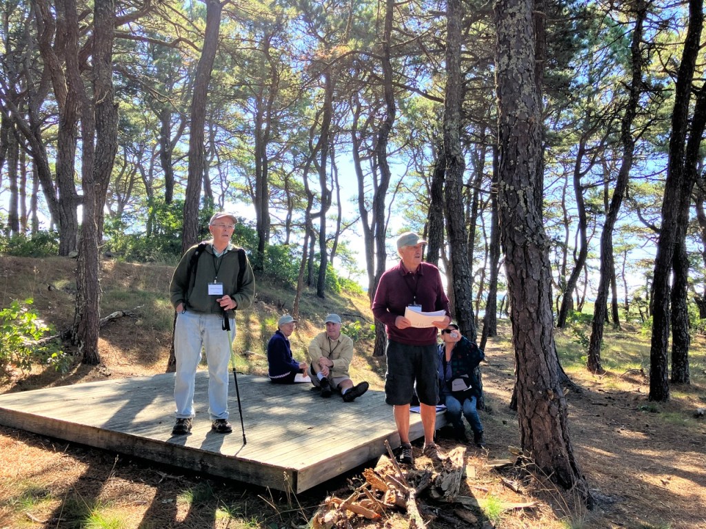
At the edge of Fox Island Marsh, Mark Robinson, Executive Director of the Compact of Cape Cod Conservation Trusts, spoke about how the WCT led the partnership that resulted in the Town, Commonwealth, and private donors raising $4.5 million to acquire 68 acres of upland for conservation. Mark was involved in the negotiations and fundraising including liaising with the Commonwealth. This assemblage is the largest conservation area north of the Orleans rotary and is an important habitat for the endangered Diamondback Terrapin.
Further along the marsh and into the woods, Denny told the story of the burial that took place a number of years ago. It was the burial of a cast iron bath tub that was acquired with the land. Trustees and AmeriCorps members, dug it out of its hole, widened the hole, turned the tub upside down and buried it. Photos of the event were passed around.
At Whalebone Point. Mark Robinson described the vista that came into view, including Indian Neck, Blackfish Creek, Lt Island, the bridge to the island, and Old Wharf Point.
As always, these walks are a group effort involving a number of our trustees.
Growth of the town
Dwight Estey used two locations to describe the relationship between the growth of the town during the 19th century driven by the mackerel fishery and today’s Paine Hollow Historic District. At Paine Hollow Landing he pointed out the abandoned location of the Southern Wharf at the end of Old Wharf Point and the long-gone Townsend Salt Works which was near where they were standing. The wharf served a few dozen two-masted and three-masted ships primarily used in the mackerel trade. Among its buildings was a salt-shed used for salting down the catch. Overall, from 1820-1850 the town population grew from 1,400 to over 2,400, schools increased from 6-12 and there were up to 100 boats in the mackerel trade.
Moving to the corner of Paine Hollow Road and Pleasant Point Road (formerly known as Hinckley Corner) he referred to Irene Paine’s book, Eva and Henry, as a reference to better understand the area. Prior to 1800 there were scattered houses of the Youngs, Riches, Wiley’s and Lombards – among others.
Within the historical district there are now seven houses associated with the Paines. They were all built in the early 19th century when the Paines were involved in the fishery. The purchase of the Southern Wharf by Collins Cole and Nathan Paine began a long history of both families settling down in this area that is sometimes referred to as “the road that time forgot.”
The contingent was told the tale of Isaac Rich who was born (1801) on Pleasant Point Road. The eldest of ten children, Isaac at age 14 moved to Boston with his father to find employment. Starting by pushing an oyster cart, at age 19 his father died and Isaac opened an oyster stall. Using earning he first invested in ships and then Boston real estate. A devout Methodist, Isaac died in 1872 as one of the richest men in Boston, leaving his entire estate for the founding of Boston University. Though worth 1.5 million when he died, the Great Fire of Boston removed half that worth.
The last site discussed was that of the Robert Young Cemetery. Started in 1799 its last burial was 1854. The stones were moved to the South Wellfleet Cemetery but the bodies were not. Only eight of the stones still exist although over a dozen bodies were buried there.
Our 15th annual walk will be held on September 16, 20203. This is a week later than usual.
The walk will cover the Fox Island Marsh and Pilgrim Springs Woodland Conservation Area.
Much of the walk will be along the shore with views of the marsh, Fox Island, Blackfish Creek, Indian Neck, Field Point, and Old Wharf Point.
The walk, which is expected to take about two hours, starts at 9:00 am. Participants are asked to arrive by 8:45. There is limited parking, so we urge you to carpool. No pre-registration is required.
Directions to the start: Take Paine Hollow Rd off Route 6. After 0.3 miles, turn right onto Baker Road and follow it to the sand road. There will be people there to assist with parking.
Be sure to wear sturdy shoes, since the terrain is mostly dirt roads and pathways with some hills. It may be muddy in spots. Don’t forget sunscreen, insect repellent, hat, and water.
The rain date is September 17.
We’re looking forward to a lovely day and hope you’ll join us.
Seth Rolbein’s latest post, Buying open space, pushing big-lot zoning, provides a straightforward discussion of the need and possibilities for affordable housing on Cape Cod. The loss of affordable housing has transformed daily life, including hollowing out communities, increasing traffic, and endangering health.
Seth shows clearly how the loss of affordable housing was not due to protecting open space for conservation and recreation. Instead, decades of zoning battles that emphasized single-family homes and ever-larger lot sizes drove up costs “and ignored alternatives like more density in well-selected places.”
Many of us grew up playing the Animal, Vegetable, Mineral? game. You had to guess an object, knowing only which of those three categories it fell into. Animal and vegetable (plant) were supposed to cover all living things.
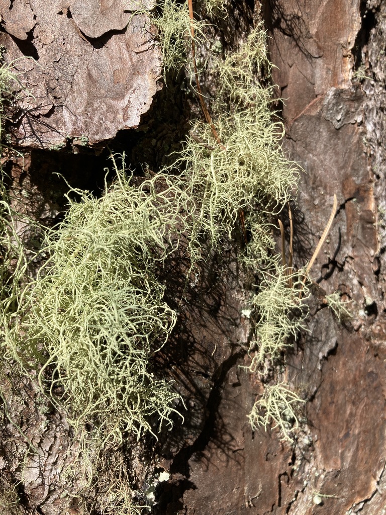
Beard lichen (Usnea), a genus of fruiticose lichen
But what if you came across some living thing that was neither animal nor vegetable? What if the thing you found looked like a plant, but wasn’t; looked like a single organism, but wasn’t; could appear as a mineral of some sort, but was full of life?
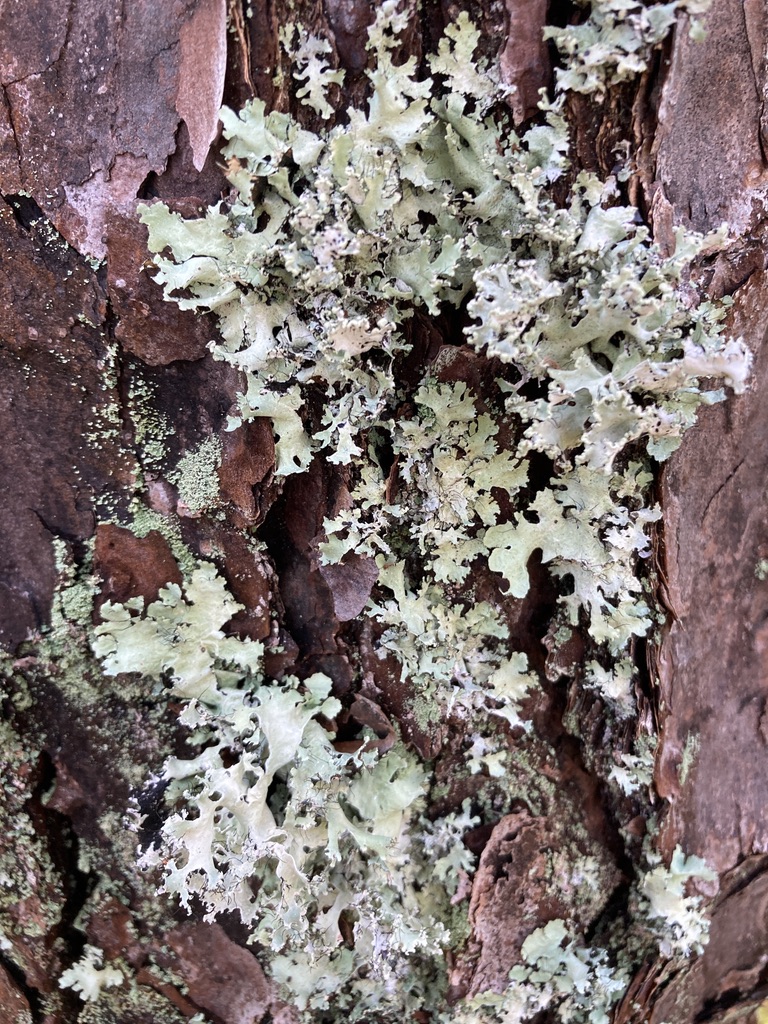
Powdered ruffle lichen (Parmotrema hypoleucinum); a foliose type
You could be looking at one of the most interesting phenomena on Cape Cod, but one that is often overlooked, even by those otherwise expert about birds, trees, wildflowers, turtles, mammals, mollusks, insects, and other fascinating flora and fauna.
That strange thing you observe might be a lichen, a composite organism made up of algae or cyanobacteria living among multiple fungi species. The fungi are in a kingdom separate from either plants or animals. That kingdom includes yeasts, molds, and mushrooms. Like animals, they cannot photosynthesize, but acquire food directly or indirectly from plants.
Within a lichen, the fungi provide structure and attachment to a tree, rock, or split rail fence. The algae contain the green pigment, chlorophyll, which gives the green color to the lichen and captures energy from the sun to support. photosynthesis.
One common type you may find is foliose, or leaf-like lichen. Another is fruiticose, reminiscent of tiny fruit trees. There are also crustose, which attach to rocks so tightly that they can’t be removed without destroying them or the rock. They seem like the Mineral in the old guessing game. Some common crustose lichen are bright orange.
Reindeer lichen (Cladonia portentosa); fruiticose
Lichens are gray when the algae components are dead or dormant, but they may turn bright green after a rain. The fungus (which surrounds the algae) soaks up water, causing its to become more transparent, and revealing the green pigment of the algae.
See what you can find the next time you venture onto a WCT trail.
The month of June has become a time to welcome students from Wellfleet Elementary School to trails sponsored by the Wellfleet Open Space Committee and the Wellfleet Conservation Trust.
The two organizations have collaborated for many years on programs for schoolchildren. One of their most important functions is to help young people appreciate the value of nature and open space.
This year Peggy Sagan from the Open Space Committee led a program for grades 3, 4, and 5, involving activities in class related to nature, conservation, and map reading, plus field trips.
Fox Island Marsh and Pilgrim Springs Woodlands Conservation Area
The classes included Melanie Griswold’s grade 3, Kristin Connolly and Tessa Wood’s grade 4, and Brendan Pursel’s grade 5. For grade 4 there was a field trip to the Fox Island / Pilgrim Springs area and for grade 5 a trip to the Herring River Overlook. Others helping Ms. Sagan at various times included John Grieb from the Open Space Committee, and Bill Iacuessa, Denny O’Connell, and Chip Bruce from the WCT.
Grade 4 explores the Fox Island Marsh and Pilgrim Spring Woodlands
At the start of our hike, we asked two students to read the text on the Robert Hankey plaque. They were stars, prompting a discussion about what a trust is and why we need to conserve open space and habitats.
Memorial for Robert Gordon Hankey at Fox Island
At the end of the hike, students recalled their best experience. Two said that they liked the fiddler crabs the most. But one said she liked the dead ones, because you could hold them more easily and look closely. Another said she liked the live ones.
One student liked sea shells along the salt marsh; another liked seeing the berries. Yet another liked hearing about how we construct trails.
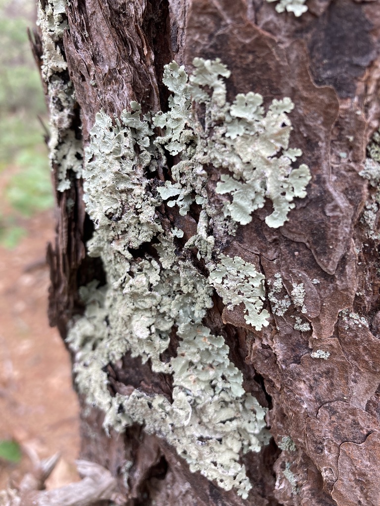
Green shield lichen on a pine tree
In notes after the field trip, students wrote things like this:
My favorite was seeing all the crabs and sea pickles. Thank you for the amazing field trip. I had the best time ever.
Thank you for teaching us a lot of nature facts that I didn’t know.
Thanks for letting us go on that really inspiring field trip!
Grade 5 explores the Herring River Overlook
Herring River Overlook trailhead
Grade 5 students at the Herring River Overlook trail were asked to observe. Within 10 seconds of starting out they had found a box turtle.
They observed many things after that in an all too short adventure. They learned about lichen and moss, bayberry and bearberry, and the glacial history of Cape Cod. They talked about the estuary with its brackish water.
Box turtle near the HRO parking lot
When we came to the last bench on a counter-clockwise circuit, the first one said, “Wow! What a view!”
Another student, already contemplating graduation, asked whether the middle school students would get to do this.
We talked about staying on the trails, both as a safety measure and to protect the fragile ecosystem.
Judging by the smiles, the many questions, and thank you notes, the students in all three grades had a great time and learned a lot.
A friend commented that he had done a lot of hiking and walking on nature trails, but that he’d only recently become aware of the many decisions and the work it took to build and maintain a trail. He would be interested to see what we do with Wellfleet Conservation Trust trails.
Protecting the site
We plan these trails to entail minimal destruction to the environment. They should be obvious so that walkers can stay on them without creating social trails through the woods. But we like them to be as unobtrusive as possible. This requires a balance of engineered and natural features.
Among other things, we cut overhanging branches that pose a hazard to walkers, but leave any vegetation higher than a Celtics player, unless it’s in danger of falling. We make the trail wide enough for anyone to walk easily, but usually require a single file. We place trail blaze arrows at confusing junctions, but try not to use more than absolutely necessary.
Visitors from Nepal helping to repair a roped off area at Herring River Overlook
In some places we’ve added stakes and ropes to discourage off trail walking. As enticing as that bushwhacking may be for some, it can be very destructive for the land. For example, at the Herring River Overlook trail, walking down the dune towards the river kills fragile lichen, moss, bearberry, mayapple, violets, sea oats, and other vegetation. That in turn can lead to serious dune erosion.
The ropes are easily bypassed, but we don’t want to mar the sites with massive barriers. We have to trust that responsible visitors will recognize the message and stay on the trail.
National Park Service plea, too often ignored
In many parks today we see the sign that “vegetation grows by the inch but dies by the foot.” That’s especially true on Cape Cod. Tenacious plants can survive despite salty winds off the sea, sandy, nutrient poor soil, and hungry wildlife, but only if we’re on their side.


You must be logged in to post a comment.